

 AERIAL SURVEY & MAPPING FLIGHTS HIRE , NAIROBI,KENYA
Kenya Aerial Survey & Photography flights are utilized using helicopters and fixed wing aircraft.Both the helicopters and fixed wing aircraft can be fitted with the equipment’s required for aerial survey & photography flights .The Beaver Turbo prop,Beaver Piston ,C-206 have the Camera Hatch inbuilt and you can install a sensor and antenna with GPS of your choice or cine-flex at your on cost .Our pilots have a wealth of experience as they have executed aerial survey and mapping for local,international organizations within Eastern and Central Africa.
Kenya national parks and game reserves has its uniqueness thus attracting tourists for example wildlife safari, ornithological safaris,cultural safaris birding safaris,walking safaris, diving and windsurfing safari,bating safaris,educational safaris among many other safaris.Aerial survey & photography air charter flights Masai Mara is the viewing of the wildlife within the game reserve and taking photographs while in the air.
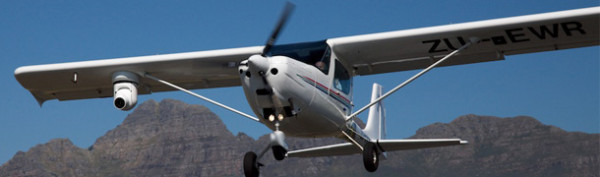
Helicopters are used for sight seeing flights at a near range as it can fly as low as 5000 feet above sea level and the angle of taking images is good.The aircraft operators in Kenya have aircraft including fixed wing twin and single engine and helicopters which are ideal for aerial survey and door or window can be removed to give the photographer spacious and an angle to be able to take the picture.
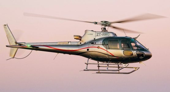
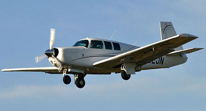
The helicopters and aircraft have camera hatch holes and the sensor thus all you need to do is to get the dimension to be able to get a camera that can fit.Kenyan airports where you will get aerial survey photography air charter flights are Wilson airport, Nanyuki airport, Mombasa Moi international airport, Lamu airport, Malindi airport,Ukunda airstrip, Kijipwa airstrip,Rea Vipingo Kilifi,Bamburi airstrip and many more others.Aerial survey, sight seeing and photography flights are normally for radiometric survey, mapping and take the physical locations of a site, building or project. Aerial survey & photography flights are normally used for mapping of taking the coordinates of certain areas including airstrips and airports and historic sites.The helicopters AS350 5 seater,Enstrom 3 seater,Bell 407 ,C-172/C-182,C-206/C-210/,PA-34 SENECA 11 ,Baron 55/58,C-208 CARAVAN, LET 410, TWIN OTTER,DONNIER 228,C406 Caravan 2 which are readily available and depending with your budget and the crew members to be on board.The hourly rate for Helicopters ranges from USD 1,650=00 to USD2,250=00per hour based on capacity and type ,fixed wing aircraft single and twin turbo prop and piston Caravan USD 1,350=00 per hour, C-172/C-182 USD 400=00 per hour,C-210/C-206 USD 650=00 per hour,Beaver Turbo prop,piston and Islander USD1,300=00 per hour ,Baron 55/58 USD 750=00 per hour similarly with PA-34 Seneca which will be determined with the distance covered and aerial survey & photography flights permits are required from the authorities before commencement.But if you utilize 40 hours in a month and sign a contract for 2 month and above further discount can be negotiated.
We will actually need the equipment’s supplied by the charterer and the specialist for photography and our work is to ensure the pilot flies within the given coordinates and abides to the photographer instructions strictly and even repeats the instruction when almost at the destination for confirmation.The vast majority of modern cameras have built-in metering systems,which work to a high standard and greatly reduce the possibility of picture failure as a result of incorrect exposure.
However ,there are many occasions when an automatic metering system may let you down for example when photographing white birds,or light co loured animals ,against a dark background or, alternatively, dark birds or animals against a light sky or background.Under such lighting conditions knowledge in the use of +/- compensation is required.In the case of white/light subjects against dark backgrounds, the metering system may well be influenced to a great extent by the dark areas,thereby over exposing your main subject.This will require you to under expose to retain detail in the important white/light subject areas. Conversely in the case of dark subjects against light skies or backgrounds,the light areas may well over influence the metering, resulting in a silhouette of the main subject.
AERIAL SURVEY & MAPPING FLIGHTS HIRE UGANDA
In Uganda aerial survey flights of the River Nile from Jinja and  Lake Albert using AS350 Chopper ,Cessna 208 cavaran,Cessna 172,Cessna 206,PA-34 Seneca 11 for sight seeing of the islands, falls,forests and hills.The major Ugandan tourists attraction areas are Queen Elizabeth,Sipi Falls, Kidepo,Murchison Falls, Bwindi, Ssese Islands,Kabalega Falls and many others.These aerial survey &photography air charter flights comes with other benefits like scenic safaris,sight seeing safaris,gorilla safaris, filming safaris birding safaris which will be done at the same time.Aircraft available for hire range from 2 seater to 18 seater fixed wing aircraft and helicopter 1 seater and 5 seater and door and window on the fixed aircraft can be removed to create room for movement and taking the right angle to be able to take clear images.
Uganda aerial survey & photography flights we utilize fixed wing aircraft and helicopters for gorilla safaris and viewing of tourists sites.The charges are friendly if you are a group as you will share among yourselves and take one aerial survey safari.Helicopters and fixed wing aircraft have camera hatch hall where acamera can be fixed to be able to take photographs.
Permits are not required unless you want to overfly major towns whereby you need to apply through the Department of Defence through the civil aviation authority.You have hire an aircraft or helicopter for aerial survey & mapping flights Uganda varying from 1 to 19 seats and helicopter from 1 to 7 seats respectively.
AERIAL SURVEY & MAPPING FLIGHTS HIRE TANZANIA
Tanzania aerial survey flights to the mining sites of diamond like Geita,Mara and Shinyanga has been done using the helicopter AS350 5 seater,Cessna 208 Caravan, Cessna 206,PA-34 Seneca 11 for inspection trips and aerial survey of the projects there.Tourist arriving at Dares Saalam international airport can charter aircraft or helicopter for aerial survey & photography flights to various tourists destinations for example Selous, Mahale, Ruaha, Serengeti,Lake Manyara, Ngorongoro Crater,Seronera,Ndutu,Klein’s Camp, Sasakwa, Kogatende, Lobo where they can do scenic of mountains, rivers the Ngorongoro crater,Olduvai Gorge,Oldonyo Lengai and do birding safaris,sight seeing.
The other air charter flights that go in hand with aerial survey & photography is filming safaris,sight seeing safaris,scenic safaris.In Zanzibar aerial survey air charter flights can be chartered to go to Karange near Tanga,Tumbatu and Mnemba Island around Zanzibar,and sight see the beaches .Helicopter from 1 seater to 5 seater excluding the pilot. and fixed wing aircraft for hire are available for 1 person up to 18 people.Mount Kilimanjaro which is next to Kilimanjaro airport is situated in northern circuit and aerial survey & photography air charter flights give the tourists an opportunity to scenic the mountain,Mt Meru, Oldonyo Lengai and Olduvai Gorge as the aircraft proceed to your destination to stay or for lunch.
For aerial survey of Mt Kilimanjaro due to bad weather in the morning it is advice to charter a private flight as from Midday to be able to see the mountain very clear and take photos or else any time earlier or late in the evening will be waste of resources.From Arusha you will also charter private air taxi for aerial survey and photography into Mwanza, Dares-Saalam,Zanzibar,Kilimanjaro and the game reserves and national parks in Tanzania.Aerial survey & Photography air charter flights are charged on an hourly basis vary from aircraft or helicopter capacity.For utilization of over 40 hours and for a period not less than 2 month the prices for aerial survey and mapping are negotiable.Tanzania aerial survey & photography flights we utilize fixed wing and helicopters which have harness where the camera can be fixed to be able to take photographs.
AERIAL SURVEY & MAPPING FLIGHTS EASTERN & CENTRAL AFRICA
We have spread our services to be able to serve our clients within Africa.We have a fleet of Beaver Turbo prop ,Beaver piston, Cessna 172,Cessna 182,Cessna 206,Cessna 210,PA-34 Seneca 11, Baron 55/58,C-208 Caravan which camera hatch hole.The beavers have the camera hatch hole and are ideal for aerial survey as they have been dominant for spraying work within Eastern and Central Africa.We provide aerial survey & mapping services on private hire,lease hire depending with your requirement.our pilots are well conversant with aerial survey and mapping services as they have carried similar projects before.
Aircraft & Helicopters are available for lease and private charter based on your requirement.But for long term projects we recommend leasing and the type of lease which is easy is wet lease opposed to dry lease.With wet lease you will only cater for crew accommodation,meals,fuel,landing,navigation,licenses and clearances to operate.While dry lease you will be audited to ensure you meet the Civil Aviation Authority standards and have qualified and AOC Admin personnel ,Air Operators Certificate,Air Service License,competent pilots,take care of aircraft maintenance which needs you have experts and experienced personnel.With dry lease you partly own the aircraft as you take care of all the costs expect the hull insurance for the aircraft while with wet lease you only take care of the operational costs.
For bookings email res@flywingsaviation.co.ke or call our emergency mobiles +254775532509,+254734403235 or What sup +254722599185
